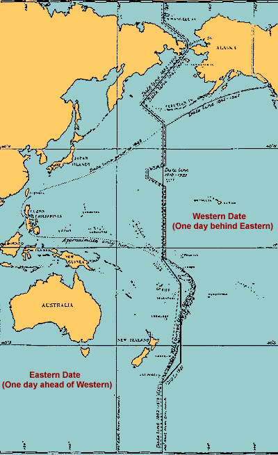
The International Date Line
The International Date Line is the imaginary line on the Earth that separates two consecutive
calendar days. That is, the date in the Eastern hemisphere, to the left of the line in the
figure, is always one day ahead of the date in the Western hemisphere. It has been recognized
as a matter of convenience and has no force in international law.
Without the International Date Line travelers going westward would discover that when they
returned home, one day more than they thought had passed, even though they had kept careful
tally of the days. This occurrence first happened to Magellan's crew after the first
circumnavigation of the globe. Likewise, a person traveling eastward would find that one
fewer days had elapsed than he had recorded, as happened to Phileas Fogg in "Around the World
in Eighty Days" by Jules Verne.
The International Date Line can be anywhere on the globe. But it is most convenient to be
180° away from the defining meridian that goes through Greenwich, England. It also is
fortunate that this area is covered, mainly, by empty ocean. However, there have always been
zigs and zags in it to allow for local circumstances.
Historical positions of the International Date Line from "Notes on the History of the Date or
Calendar Line," in The New Zealand Journal of Science and Technology, Vol. XI, pp.
385–388
Over the years, the position of the International Date Line has changed several times. Until
1845, the Philippines were on the eastern side of it (the same side as the United States). It
was on the eastern side of the line because it was a Spanish colony and most Europeans arrived
there via the Spanish colonies in South America. Indonesia, almost directly to the South of the
Philippines, was a Dutch colony and most European arrivals came via the Cape of Good Hope. Thus
Indonesia was to the west of the International Date Line. After the independence of the South
American countries, most people traveling to the Philippines also came by way of the Cape of Good
Hope, so it was decided to change from the east of the line to the west of the line. Alaska,
originally claimed by Russia, was to the west of the International Date Line because most
travelers arrived there by way of Siberia. When the United States bought Alaska in 1867 the line
was moved to the west of it. In 1995 Kiribati moved
a large segment of it to the east, so that the entire nation would be on the same side of the
International Date Line. As a result, the line is as far East as 150°, farther east than
Honolulu. The most recent change in the line was at midnight on the beginning of 2011 Dec. 31
(local time)1 when
Samoa
moved from the eastern to the western side of the International Date Line. As with all other
changes in the International Date Line, the change was made by a government with local interests.
The position given on most maps is the line drawn by the British Admiralty in 1921.
1 There was no Friday, December 31, 2011 in Samoa.
References
H.O. Bull. (1938) Questions and Answers No. 134
Lamont, R. (1921) "The International Date Line," Pop. Astron., 29, 340-348
Leigh-Browne, F.S. (1942) "The International Date Line," Geograph. Mag., Apr. 1942, 302-306
U.K. Admiralty (1930) "Notes on the History of the Date or Calendar Line," New Zealand J. Sci. Tech., 11, 385-388
