2017 August 21 Total Solar Eclipse
If, during the progress of a total [solar] eclipse, the gradually
diminishing crescent of the sun is watched, nothing remarkable is seen until
very near the moment of its total disappearance. But, as the last ray of
sunlight vanishes, a scene of unexampled beauty, grandeur, and
impressiveness breaks upon the view. The globe of the moon, black as ink, is
seen as if it were hanging in mid-air, surrounded by a crown of soft,
silvery light, like that which the old painters used to depict around the
heads of saints. Besides this "corona", tongues of rose-colored flame of
the most fantastic forms shoot out from various points around the edge of
the lunar disk. Of these two appearances, the corona was noticed at least as
far back as the time of Kepler; indeed, it was not possible for a total
eclipse to happen without the spectators seeing it. But it is only within a
century that the attention of astronomers has been directed to the
rose-colored flames, although an observation of them was recorded in the
Philosophical Transactions nearly two centuries ago. They are known by the
several names of "flames," "prominences," and "protruberances."
— Simon Newcomb. 1878. Popular Astronomy. New York: Harper & Brothers. p. 252
On 2017 August 21, a total solar eclipse was visible to fortunate observers
in the United States along a narrow band, approximately 73 miles (118 km) wide,
that crosses twelve states from Oregon to South Carolina.
Calculate local circumstances
Major U.S. cities in the path of totality: Casper, WY; Kansas City, KS; Jefferson City, MO;
Kansas City, MO; Lincoln, NE; Salem, OR; Columbia, SC; Greenville, SC; Nashville, TN, St. Louis, MO; Charleston, SC
Use the form below to calculate the local circumstances. To find coordinates of cities or towns in the U.S. or its territories, or to convert between Degrees-Minutes-Seconds (DMS) and Decimal Degrees, use the respective buttons.
For other eclipses, try our
Solar Eclipse Computer. Times are
given in UT1; for help converting them to local time, see
U.S. Time Zones. Notes on the local eclipse circumstances are located at the bottom of this page.
View US map and circumstances
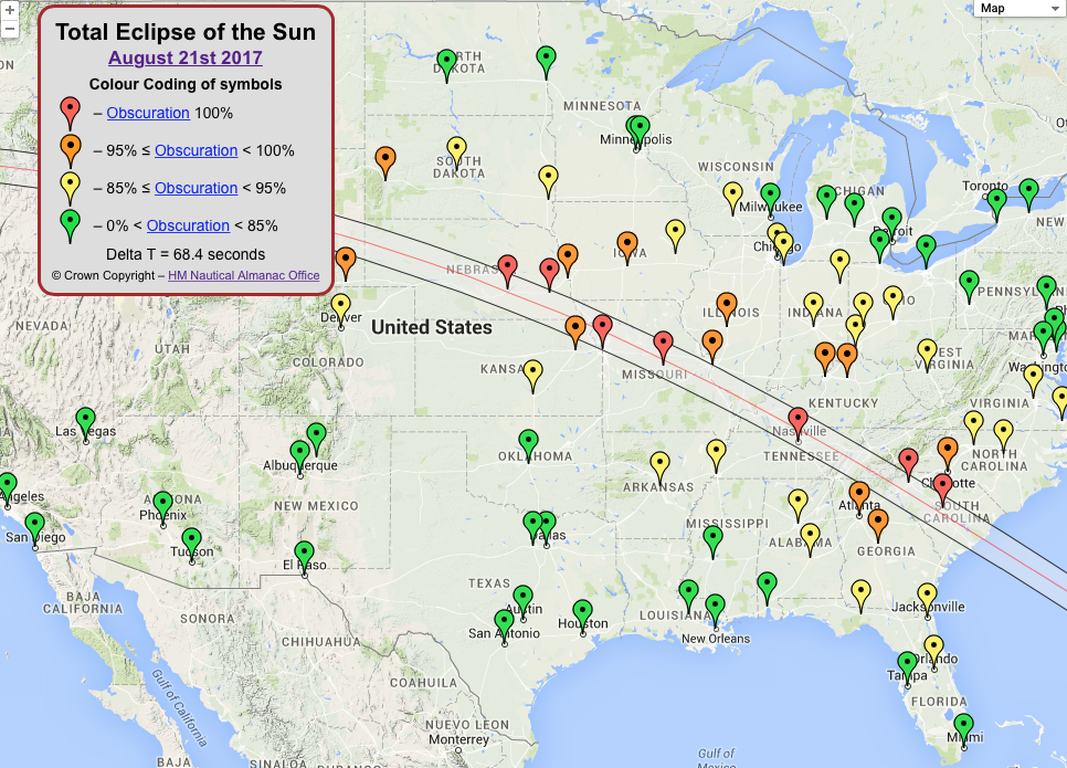
His Majesty's Nautical Almanac Office
(HMNAO), United Kingdom Hydrographic Office provides a 2017 total solar eclipse map. The map contains detailed information about the
eclipse for selected US cities, including local circumstances, animations,
and diagrams. Please click on the image to visit the full map.
View global map and circumstances (Eclipses Online Portal)
The
Eclipses Online Portal
provides diagrams and animations showing the global
circumstances and local circumstances at selected locations. The Portal is a
joint effort with
His Majesty's Nautical Almanac Office
, United Kingdom Hydrographic Office.
Times are given in UT1; for help converting them to local time, see
World Time Zone Map.
View global visibility map (The Astronomical Almanac)
Preliminary Eclipse Visibility Map from The Astronomical Almanac
(explanation of map).
For visibility maps of other eclipses, see Eclipses of the Sun and Moon.
View circumstances at
Shawnee National Forest
, Illinois, site of maximum eclipse
Local circumstance diagram for the location of maximum duration of totality (from HMNAO).
General eclipse resources
Notes
The table of local circumstances gives the UT1 time of each eclipse "event"
that is visible from the location. The
altitude
and
azimuth
of the Sun at each of the events is given as well. The azimuth is reckoned eastward from North. The altitude is corrected for
refraction
assuming standard atmospheric conditions.
The computation of Eclipse Local Circumstances is started by iteratively computing
topocentric positions of the Sun and Moon to find the time of Maximum Eclipse.
Another series of position computations is performed going backwards and
forwards from the time of Maximum Eclipse to find the times of contacts. The
solar and lunar angular diameters are calculated at each position using radius values adopted by the International Astronomical Union (Sun 696000 km; Moon 1737.4 km) to determine if contact conditions
have occurred. Lunar limb profiles and center of mass/center of figure corrections are not used.
After contact times have been computed, a check is made to determine if Sunrise
and/or Sunset occurred during the course of the eclipse. If so, the time of
Sunrise and/or Sunset is computed.
The body of the table contains the time of each contact point, the Sun's
topocentric position at that time, and its Position and Vertex
Angles. The time of sunrise or sunset is also noted in the table if it
occurs during the eclipse. The summary at the bottom contains the
Duration, Magnitude, and Obscuration.
The Position Angle of a given contact point on the solar limb is
measured eastward (counterclockwise) around the solar limb, from the point on the
Sun that is farthest north.
Vertex Angle is similar to Position Angle, except that it is
measured from the point on the Sun that has the highest local altitude.
Duration is the amount of time from the beginning of the eclipse to the
end.
Duration of Totality is the amount of time from the beginning of the
central phase eclipse to the end of the central phase. For an annular solar eclipse,
it will read Duration of Annularity.
Magnitude of the eclipse is the fraction of the apparent diameter of
the solar disk covered by the Moon at the time of greatest phase, expressed in
units of solar diameter.
Obscuration is the percentage of the area of the apparent solar disk
obscured by the Moon at maximum eclipse.
Additional eclipse defintions are available in the
Astronomical Almanac Glossary
.
